Amérique du Sud
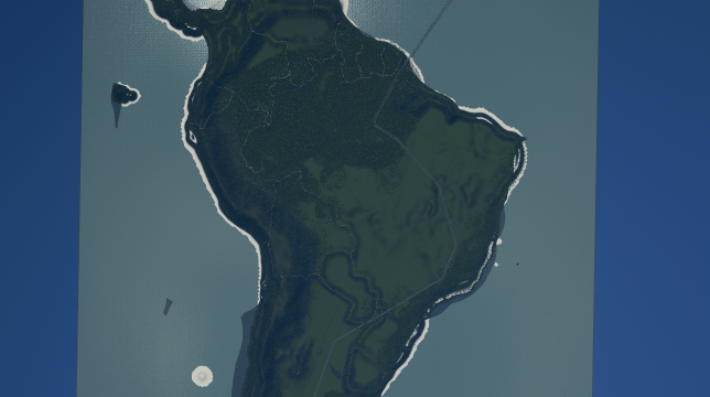
L’Amérique du Sud est un continent ou un sous-continent et la partie méridionale de l’Amérique. Il est situé entièrement dans l’hémisphère ouest et principalement dans l’hémisphère sud. Il est bordé à l’ouest par l’océan Pacifique et au nord et à l’est par l’océan Atlantique. L’Amérique centrale, qui relie le sous-continent à l’Amérique du Nord, et les Caraïbes sont situées au nord-ouest.
Le portugais et l’espagnol sont les deux langues dénombrant le plus grand nombre de locuteurs en Amérique du Sud.
L’Amérique du Sud fut nommée, à Saint-Dié-des-Vosges en 1507, par les cartographes Martin Waldseemüller et Mathias Ringmann d’après Amerigo Vespucci, qui fut le premier Européen à suggérer que l’Amérique n’était pas les Indes mais un Nouveau Monde inconnu des Européens.
L’Amérique du Sud a une superficie de 17 840 000 km2, soit 11,9 % de la surface des terres émergées de la Terre. En 2015, sa population est d’environ 410 millions d’habitants1. Le gentilé de ses habitants est les « Sud-Américains ». L’Amérique du Sud est classée quatrième continent en superficie (après l’Asie, l’Afrique et l’Amérique du Nord) et cinquième en nombre d’habitants (après l’Asie, l’Afrique, l’Europe et l’Amérique du Nord).
version anglais
South America is a continent in the Western Hemisphere, mostly in the Southern Hemisphere, with a relatively small portion in the Northern Hemisphere. It may also be considered a subcontinent of the Americas,[5][6] which is how it is viewed in the Spanish and Portuguese-speaking regions of the Americas. The reference to South America instead of other regions (like Latin America or the Southern Cone) has increased in the last decades due to changing geopolitical dynamics (in particular, the rise of Brazil).[7][additional citation(s) needed]
It is bordered on the west by the Pacific Ocean and on the north and east by the Atlantic Ocean; North America and the Caribbean Sea lie to the northwest. It includes twelve sovereign states (Argentina, Bolivia, Brazil, Chile, Colombia, Ecuador, Guyana, Paraguay, Peru, Suriname, Uruguay, and Venezuela), a part of France (French Guiana), and a non-sovereign area (the Falkland Islands, a British Overseas Territory though this is disputed by Argentina). In addition to this, the ABC islands of the Kingdom of the Netherlands, Trinidad and Tobago, and Panama may also be considered part of South America.
South America has an area of 17,840,000 square kilometers (6,890,000 sq mi). Its population as of 2016 has been estimated at more than 420 million.[1] South America ranks fourth in area (after Asia, Africa, and North America) and fifth in population (after Asia, Africa, Europe, and North America). Brazil is by far the most populous South American country, with more than half of the continent’s population, followed by Colombia, Argentina, Venezuela and Peru. In recent decades Brazil has also concentrated half of the region’s GDP and has become a first regional power.[7]
Most of the population lives near the continent’s western or eastern coasts while the interior and the far south are sparsely populated. The geography of western South America is dominated by the Andes mountains; in contrast, the eastern part contains both highland regions and vast lowlands where rivers such as the Amazon, Orinoco, and Paraná flow. Most of the continent lies in the tropics.
The continent’s cultural and ethnic outlook has its origin with the interaction of indigenous peoples with European conquerors and immigrants and, more locally, with African slaves. Given a long history of colonialism, the overwhelming majority of South Americans speak Portuguese or Spanish, and societies and states reflect Western traditions.
version espagnol
América del Sur, Sudamérica o Suramérica8 (también llamada América Meridional, América del Mediodía, América Austral o Continente Meridional) es el subcontinente austral de América, o también considerado por muchos uno de los continentes que conforman el supercontinente América.9 Está atravesada por la línea ecuatorial en su extremo norte, quedando así con la mayor parte de su territorio comprendida dentro del hemisferio sur.
Está situada entre el océano Atlántico y el océano Pacífico quienes delimitan los extremos Este y Oeste respectivamente, mientras que el mar Caribe delimita por el norte y el océano Antártico su extremo sur. Está conectada con América del Norte por el estrecho puente territorial que representa América Central. América del Sur es la zona terrestre más próxima a la Antártida a través del pasaje de Drake al sur. Ocupa una superficie de 18,2 millones de km², lo que representa un 42,9 % del continente americano y un 13,0 % de las tierras emergidas,10 y está habitada por el 6,5 % de la población mundial.11
América del Sur está conformada por un conjunto de trece países soberanos: Argentina, Bolivia, Brasil, Chile, Colombia, Ecuador, Guyana, Paraguay, Perú, Surinam, Uruguay y Venezuela, una región de Francia12 (Guayana Francesa) y cinco dependencias de otros estados. Brasil concentra aproximadamente la mitad de la población y la producción económica de la región.13 Los países que bordean el mar Caribe —Colombia, Venezuela, aunque se suele incluir a Trinidad y Tobago (por encontrarse sobre la plataforma continental), Guyana, Surinam, también la Guayana Francesa, que es un departamento de ultramar de Francia, Aruba, Curazao y la isla de Bonaire pertenecientes al Reino de los Países Bajos— se conocen en conjunto como el Caribe sudamericano, mientras que Argentina,Chile, Uruguay y el sur de Brasil, forman el Cono Sur, una región del subcontinente que se caracteriza por los más altos estándares de calidad de vida y desarrollo en relación al resto de Latinoamérica.14151617 Colombia y Venezuela, además de estar en la región Caribe, pertenecen también junto a Bolivia, Chile, Ecuador y Perú a la zona andina.
Desde el siglo XVI hasta principios del siglo XIX la mayor parte de América del Sur estaba dividida en colonias gobernadas, mayoritariamente, por España y Portugal, seguidas por una colonia del Reino Unido, una de Francia y otra de los Países Bajos las cuales se fueron convirtiendo en Repúblicas, con la excepción de la Guayana Francesa convertida en Departamento de Ultramar francés (Región Ultraperiférica europea) y las Islas Malvinas e islas vecinas. Si bien, el límite actual de América del Sur con América Central se ubica en una línea imaginaria en la selva del Darién, fue a partir de la construcción del canal de Panamá que se empieza a asociar a este país con América Central en medios anglosajones. Finalmente en el año 1955, Panamá pasa a formar parte de América Central geográficamente, pero mantiene lazos históricos y culturales con América del Sur.1819
Required items:
Click the title to search on this site.
Just Tropical — Steam Workshop
Unlimited Outside Connections (Beta) — Steam Workshop
Fall Tree — Steam Workshop


