Lake Thun
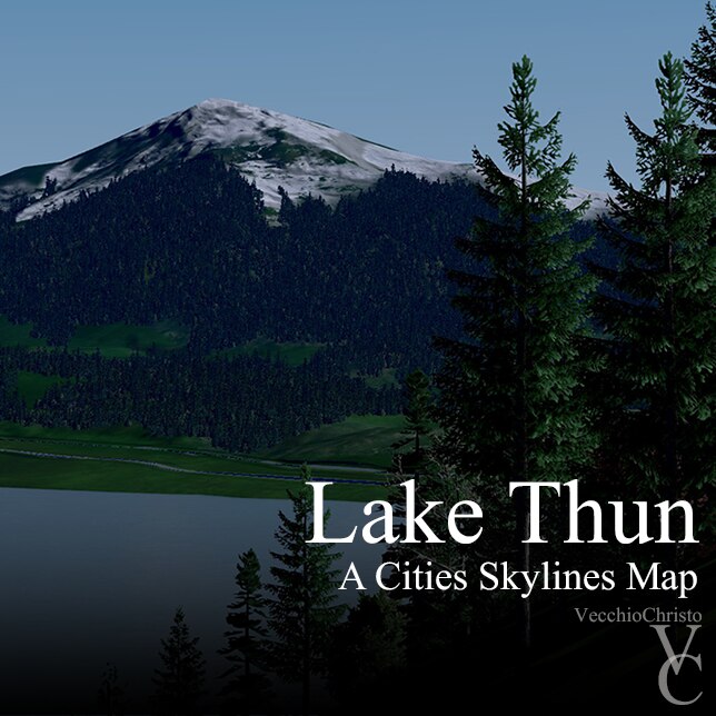
Lake Thun by VecchioChristo
This map depicts the lake Thun area of Switzerland. It is a culmination of a years worth of work refining methods and techniques as well as research of the area. It is a reasonably accurate map for cities skylines, however some road placements in confined areas have been moved as much as 40 meters to allow for proper functionality. Highway interchanges and roundabouts are somewhat larger than actual as required for proper traffic flow. Terrain elevations are reasonably accurate with the exception of higher mountains which far exceed the games 1024 meter maximum. In other words the real mountains are considerably higher than depicted on this map.
This map is intended to be used with all 81 tiles activated but is not absolutely necessary.
This map will flood on initial startup but will quickly dissipate and will not reoccur once your game has been saved.
You can speed up the drying time by speeding up the simulation. Takes about 30 to 60 seconds.
This occurs because there is only around a 1 1/2 meter difference between ground and road surfaces and the water level.
A word about water flow and sewage:
The real world water flows in a northerly direction from Lake Thun into the Aare river. I reversed this flow from the beginning of the map construction so as not to have sewage flowing up the river into inhabited areas. During testing in game however, sewage over time created an ugly blight on the lakes surface which I considered unacceptable. To remedy this I placed a gang of 6 sewage outlets at the northern map border and ran a pipe through the start square.
I highly recommend using Traffic Manager to refine traffic flow through the cities many roundabouts and highway merge lanes. I would have done this but apparently this is not possible in the map editor.
I have placed the same overlay map I have used in the making of this map on Google Drive which you can access here. https://drive.google.com/file/d/1mE-iwUChWPDPvg9iwLI7qefiX0MNypoT/view?usp=sharing
Invisible networks have been used in multiple locations on this map to flatten river bottoms and also to make pedestrian connections between roads and quays. You can locate these if needed with the "Move it" marquee selector.
Because of the hilly nature of this area many residential areas in Spiez and up in the surrounding hills would be better served with houses and buildings that do not flatten terrain. You can accomplish this in asset editor and I encourage
other artist who wish to make assets for this map to make building assets that do not flatten terrain.
The loading screen mod will show several assets missing 3 "SN USA barrier" and "Railway Fishplate", they are not
missing. I use the NAF 2 and 3 lane highways only for tunnels so that we have a rendered interior. And railway fishplate is apparently an artifact.
The no Radioactive Desert Mod settings were configured with the map. If these settings dont migrate with your download The first 2 buttons should be toggled on, "no orange dead trees at shoreline, no shoreline ground color" and the second button dealing with "polluted areas.
Daylight Classic Mod should just have "classic sunlight color" and "classic sunlight intensity" checked.
You can see the complete sequence along with tutorials of the making of this map on my YouTube channel
https://www.youtube.com/channel/UCtsrE5g-7lh2owI6pZd56yQ
Required DLC:
These DLC should be installed in order to use this item.
Cities: Skylines - Mass Transit


