Lines Of Nazca
Welcome to Nazca! This map is a recreation of the plateau where the famous lines can be found, north-west of the town of Nazca, and part of the nearby Ingenio valley. The map is also dedicated to Maria Reiche[en.wikipedia.org], a matematician who studied, and helped conserve, the lines during her life, born on this day (15th May) in 1903.
—-DETAILING—-
Using the overlay (that you can find among the screenshots*), and with the help of Maps[www.google.it], I have traced the path of the main lines that can be seen from above, using the vanilla gravel path. I have used a large amount of nodes and segments, so the game may take a bit to load them once the map has been opened. If this happens, just wait a few moments and everything will load as it should. Once the paths are loaded, the game should run smoothly without any lag when getting close to them.
I have used a custom path gravel to build the figures. This path, however, can sometimes behave in a weird way. If this happens (eg. a figure sinks into the ground) check the workshop page of the drawings for the solution.
Because of the way the game renders tiles, you won’t be able to see the vanilla paths until you buy that specific tile. To fix this you can either use the 81 Tiles mod to unlock every tile or, if you don’t want to buy them, the Common Ground mod.
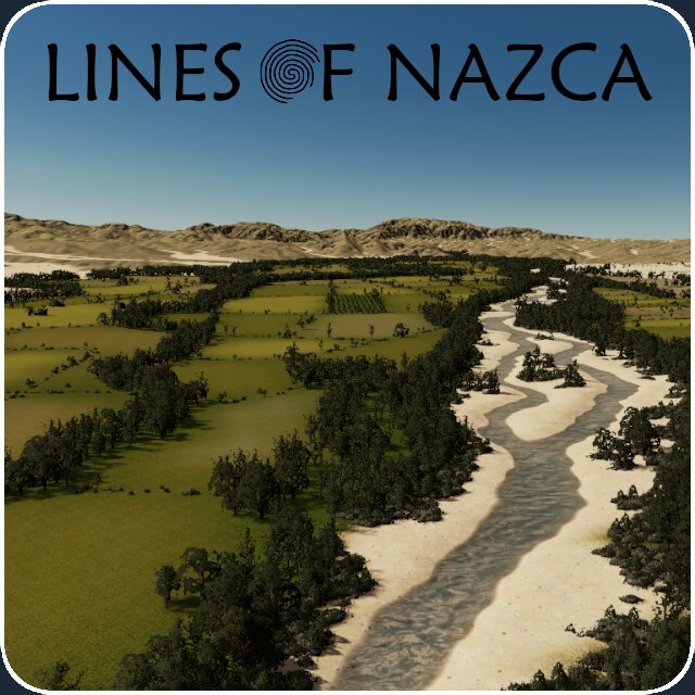
As you may notice, the rest of the map is very lightly detailed, with large chunks being completely empty (like the desert in the north). This is because I thought that the dry rivers and the terraforming alone would be enough to make it feel like a desert.
The heightmap I used was quite smooth and pixelated in places. I had to spend a lot of time terraforming it and adding a lot of erosion lines, while still following the real life terrain. I hope the end result is not too far from reality
The fields in the valley have been traced with the overlay too, although the smaller ones have been merged together to make resource painting a bit easier.
In the start square you’ll also find the museum dedicated to Maria Reiche, recreated with some vanilla assets.
The screenshots have been taken with the Nemesis LUT, with no additional graphic mods. I tried recreating the same conditions using Relight but couldn’t really get the same result. In the last screenshot you’ll find some relight settings that come a bit close and that you can tweak a bit as you please, but using the map without being subscribed to any viual mod (relight, eyecandy…) will get you the right look a lot quicker.
The map has only 154.316 trees, all vanilla, so this should be easy to run on most computers.
Here you can find the settings for the two brushes I used in the map:
Brush for forests:
Eastern Cottonwood: 100%
Horse Chestnut: 30%
Live Oak: 100%
Brush for field hedges:
Eastern Cottonwood: 16%
Wild Hedge: 100%
Tall Grass Cluster: 100%
Young Linden: 40%
Pacific Rhododendron: 12%
Live Oak: 7%
—-GAMEPLAY—-
The highway system consists of the Panamericana Sur, going from north-west to south-east, and the Carrera a El Ingenio, crossing the Ingenio valley towards the east. Your start square lies where these roads encroach.
In case you’re planning to build a big city and would like a stronger highway network, I built an undergroung 3 lane highway and railway that cross the Ingenio valley from west to east (passing through the start square).
To prevent unnecessary traffic going through your city once you connect this underground network to the national road, I built some roads near the edge of the map that should give dummy traffic a quicker route out of the map.
The start square has a small river going through it. I suggest using it for drawing water. West of the start square you’ll find a small lake (which I have extended a little bit) that you can use to dump sewage into.
4 Highway Connections
2 Railway Connetions
0 Ship Routes
2 Plane Routes
* This image is slightly smaller than the one I used, because of Steam’s upload limits. You can download the original one from the SkyDark[heightmap.skydark.pl] website by inputting the following coordinates:
Longitude: -75.13470
Latitude: -14.69396
Min Height: 228.9
Max Height: 1047.3
Water contours: false
Height contours: false
Zoom: 11.493721989208177
Required items:
Click the title to search on this site.
Gravel path 2m — Steam Workshop
NAF Small National Roads — Steam Workshop
NAF Street and Traffic Lights — Steam Workshop
Railway Barriers (American) — Steam Workshop
Peruvian Pampas Theme — Steam Workshop
Nemesis LUT — Steam Workshop
Lines Of Nazca - Asset Pack — Steam Workshop


